Keep up to date with new features, geographic expansion, case studies, and more by signing up for our newsletter here.
April 2024
February 2024
Planscape :: February 2024 🌲🌳
USDA joins Planscape, UMRWA case study, new video and more...
February updates ⏩
Planscape is a free decision support tool built to maximize wildfire resilience and ecological benefits across the State of California.
Planscape helps regional planners prioritize landscape treatments to mitigate fire risk, maximize ecological benefits, and help California’s landscapes adapt to climate change
Planscape is a collaborative effort by the California Natural Resources Agency, the USDA Forest Service, The University of California, The USDA Climate Hubs, and Spatial Informatics Group (SIG) with support from Google.org
New Partner! 🪇
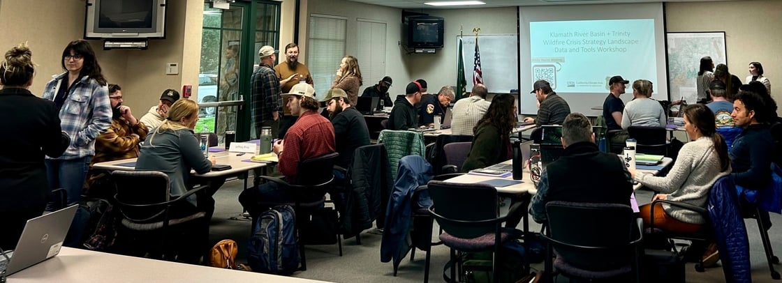
We’re delighted to welcome the USDA Climate Hub to the Planscape Cooperative. The team, based out of UC Davis, brings a new depth of scientific knowledge and rigor to the team. They will be focused on user engagement, running workshops, training upcoming instructors, and more. Last week, they designed and delivered a workshop in Northern California, focused on the Klamath River Basin and Shasta Trinity crisis strategy landscapes. A warm welcome to Steve, Jen, Jess and colleagues!
Cut! 📽️
It’s Oscar season, and the new Planscape video is award eligible. Enjoy your own private viewing here. If you're wondering how to get started with Planscape, this is the best place to start. Please share!
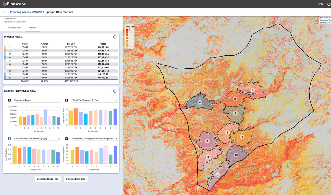
The Planscape Cooperative is honored to be working with the Upper Mokelumne River Watershed Authority (UMRWA) in California’s Sierra Nevada on the Forest Projects Plan (FPP), Phase 2. FPP is a large-landscape forest and ecosystem health partnership effort between UMRWA and the USDA FS located on the Eldorado National Forest, Amador Ranger District and the Stanislaus National Forest, Calaveras Ranger District in and immediately adjacent to the Upper Mokelumne River watershed. The Planscape Cooperative is working collaboratively with UMRWA to produce a 10-year plan to increase wildfire and ecological resilience in and adjacent to the watershed within the approximately 260,000-acre project area. Read more about the work here.
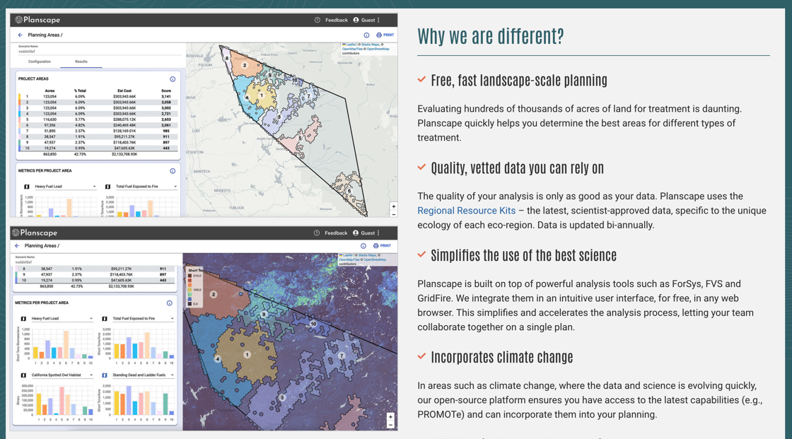
How are we different?
We're often asked how Planscape is different. We've summarized below, and expanded here.
Free
Planscape is free (and always will be) for anyone to use through a web browser. Our goal is to democratize the best data and science to help anyone and everyone make the best planning decisions.
Open Source
Planscape code is openly available for anyone to use, with a public-domain, no-copyright license.
We welcome collaborators. Reach out if you’d like to contribute.
Open Science
The science and models used by Planscape are transparent. There is no ‘black box’. We build easy-to-use interfaces, so you don’t need to be an expert to enter your goals and constraints or to understand the results – and we’re always transparent about how our models work.
Built on the best peer-reviewed science, we are not developing new science – Planscape brings best-of-breed tools like ForSys, FVS, Gridfire, Treemap, PROMOTe, and others in an easy-to-use tool through a web browser. Though these tools are available and open, they can require significant investment in learning - the Planscape platform makes them accessible to all. Reach out if you think we’re missing tools or models that should be incorporated.
Open Data
Planscape ingests hundreds of scientifically approved data layers. The sources, descriptions, and vintages of each are transparently provided. Users can download any data layers used in Planscape.
Governed
Planscape is governed by USFS, the State of California, The California Wildfire & Forest Resilience Taskforce, the University of California, Google.org, and others. No entity has commercial ownership of Planscape, or profits from its success. We welcome new members of the Planscape cooperative.
Climate Change Models
We believe we can’t achieve wildfire, ecological, watershed, or other resilience without considering the pressures of climate change. By building in future-facing models, we help planners understand where best to apply efforts today.
Planscape :: Why do forest planners like to collaborate?
Planscape launches new features.
April updates ⏩
Q. Why do forest planners like to collaborate?
(Scroll ⬇️ for the answer)
NEW! Collaboration in Planscape 👯👯👯
Building on last month’s launch of sharing for Explore, we’re excited to have launched our third user journey - Collaborate
Collaboration is a key part of developing landscape treatment plans. Planning always involves a team of experts who need to easily contribute scenarios, as well as be able to view and comment upon other planners’ work. Planscape now allows you to share your Planning Areas, and their associated Scenarios, with other users that you select.
There are two ways to share a Planning area.
Start from the Planning Area main page which lists all of your plans, select the plan you want to share, and then select the “Share” button at the bottom of the screen.
2. Start from the Plan Scenario list page, and select “Share” from the menu bar.
After sending the invitation to join in the plan, your colleague(s) will receive email invitations. Those invitations will include a link to the planning area.
To facilitate collaboration, “Notes” can be added to planning areas by any plan collaborator. Notes are simple text comments that are made by users to add context or information about the plan.
To add a note, click on the “Notes” tab at the top left of the scenarios screen, and start to type your note into the “Add a Note” box at the bottom of the column.
There are four access levels for Plans with different capabilities:
Creator
Creates the original planning area.
Owner
Can access, view, create, invite and change permissions.
Collaborator
Can access, view and create scenarios.
Viewer
Can view all scenarios.
More details on Collaborate can be found in our User Guide
Earlier this month we were in Escondido for the Southern California Wildfire Task Force meeting. Thanks to everyone who stopped by the table to check out the latest tool and pick up stickers, and to Lisa Lien Mager, Richard Barhdyt and Dr John Battles for talking about Planscape on stage.
Planscape is a free decision support tool built to maximize wildfire resilience and ecological benefits across the State of California.
Planscape helps regional planners prioritize landscape treatments to mitigate fire risk, maximize ecological benefits, and help California’s landscapes adapt to climate change
Planscape is a collaborative effort by the California Natural Resources Agency, the USDA Forest Service, The University of California, The USDA Climate Hubs, and Spatial Informatics Group (SIG) with support from Google.org
New Plan functionality. New site. Statewide coverage. Monthly update from Planscape.
2024. Let's go! ⏩
Planscape is a free decision support tool built to maximize wildfire resilience and ecological benefits across the State of California.
Planscape helps regional planners prioritize landscape treatments to mitigate fire risk, maximize ecological benefits, and help California’s landscapes adapt to climate change
Planscape is a collaborative effort by the California Natural Resources Agency, the US Forest Service, The University of California, and Spatial Informatics Group (SIG) with support from Google.org.
We’ve been too quiet for too long, but we’ve been busy! Here’s what we’ve been cooking up…
Covered California 😎
No, not health care. In Q4 2023, we extended Planscape to Northern California, and now are live across all 4 regions of the state.
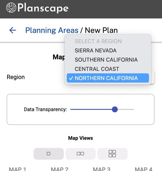
This month, we launched the Plan journey in Planscape.
Helping you determine the best locations for land treatment in your area of interest is the core capability of Planscape. Plan is built on top of ForSys, which is an open source tool developed by the USDA Forest Service. You can create a new plan by drawing a polygon or uploading a shape file.
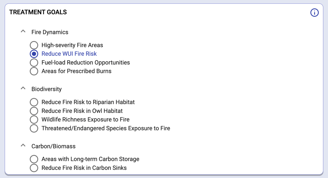
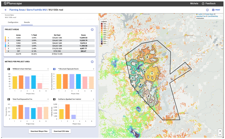
You can select from a range of common goals and refine these with constraints and filters. Planscape then returns recommended project areas, an analysis of each area against your goals, and the most relevant metrics.
You can run many different scenarios, and all are saved against your user account. Each can be accessed later, shared with colleagues, or downloaded.
Check it out and tell us how we can make it better. We're grateful for your feedback!
$2.4m from Google.org 🙌
Google.org was instrumental in the conception and launch of Planscape, providing a team of over 20 Google.org Fellows working pro-bono on the project over an 18 month period. The fellowship ended in September 2023, but Google.org generously made a $2.4m grant in December 2023 to support the ongoing development and expansion of Planscape. Thanks, Google.org!
(A more formal announcement will follow, so please don’t share this news outside of the Planscape community - thanks!)
This acceleration will focus on incorporating treatment types effects analysis as part of the Impact journey. This need has been identified by the user community (CAL FIRE, USFS, Planning Cooperatives, etc.) as critical for permitting and outcome monitoring/measurement. We are leveraging tools such as Treemap, FVS, and open-source wildfire models. First release is anticipated late-Q2/early-Q3 2024.